Image Credit: CFJC Today
LOOK AT THIS PHOTOGRAPH

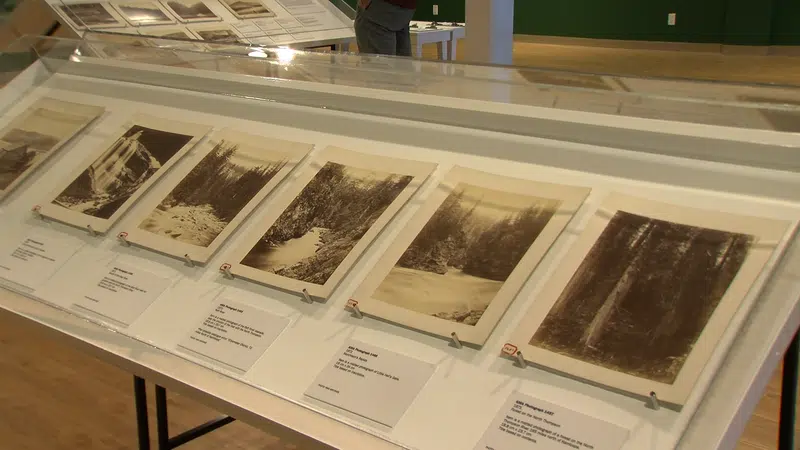
Kamloops Museum explores area’s history through Geographical Survey photographs

Jun 11, 2019 | 5:19 PM

KAMLOOPS — In 1871, Kamloops was just a pit stop on fur trading routes, a small fort at the confluence of two rivers.

It wasn’t yet a guarantee that 12 years later, it would become a stop on the Canadian Pacific Railway. Benjamin Baltzly was a photographer and part of the original geographical survey that helped map the route of the railway. Now, some of his photos are being showcased at the Kamloops Museum and Archives.

“Baltzly was a photographer from Montreal, and he took a bunch of photos of the BC Interior in 1871,” Museum Curator Matt Macintosh explains.

Almost 150 years after the photographs were taken, they’re still stunning. Images of the Fraser and Thompson Valleys, from Vancouver to the Rocky Mountains; they were taken for a purpose.

“In 1871 B.C. was joining Confederation,” Macintosh says. “Sir John A. MacDonald was prime minister, he delivered a promise of a railway that would connect B.C. to the eastern provinces. Sanford Fleming was the Chief Engineer, he enlisted the Geographical Survey of Canada to come in and scope through BC and the prairies to find the best, most resource-rich, and favorable route to draw in what was to be the Canadian Pacific Railway.”

Baltzly, the intrepid photographer, was far from just adequate.

“They hired him specifically because he had a real artist’s eye,” Macintosh says. “What we have here are real scientific documentation of the times, some of the earliest photos of Kamloops, as well as artistically very sophisticated photographs.”

The exhibit is more than merely old photographs. Included are copies of Baltzly’s original notes, as well the locations where the pictures were taken. The museum also hired photographer, Cory Hope, to recreate some of Baltzly’s authentic images in a modern setting.

For Macintosh, the photos are a stunning snapshot into the history of the region at a critical time in the province’s history.

“They’re a really complete record of this moment in B.C.’s history,” Macintosh says. “With all the ways we’ve allowed people to step into these photographs, they have a real tangible connection into B.C.’s entrance into Confederation.”

The exhibit, “Interior Monologues: Benjamin Baltzly and the Geographical Survey of BC,” is on at the Kamloops Museum and Archives until early November.

View Comments