Image Credit: BCCDC
COVID-19

BCCDC update shows 117 COVID-19 cases in Kamloops last week, high spread rates in Merritt, Cariboo

Feb 3, 2021 | 5:06 PM

KAMLOOPS — The latest COVID-19 data broken down by community in B.C. shows a high level of spread continuing in the Kamloops area.

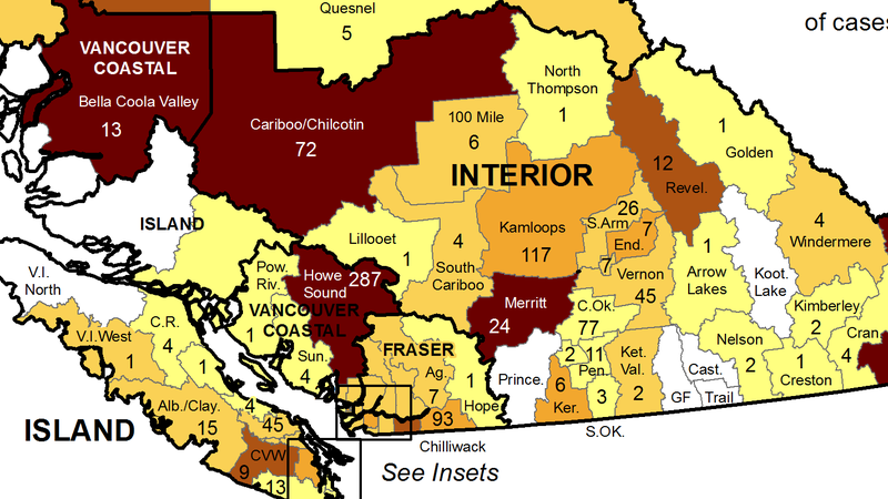
The Local Health Area (LHA) map provided by the B.C. Centre for Disease Control (BCCDC) was updated Wednesday (Feb. 3).

It shows 117 cases in the Kamloops area for the week of January 24 to 30. That is down by just seven from the previous week.

Per capita, spread was higher last week in nearby communities Merritt and the Cariboo/Chilcotin, which includes Williams Lake.

Below are the new case totals for communities surrounding Kamloops:

  • Cariboo/Chilcotin – 72 (down by 48 from last week)
  • North Thompson – 1 (up by 1)
  • 100 Mile House – 6 (down by 7)
  • South Cariboo – 4 (up by 1)
  • Lillooet – 1 (unchanged)
  • Merritt – 24 (up by 9)
  • Vernon – 45 (down by 14)
  • Armstrong-Spallumcheen – 7 (up by 2)
  • Enderby – 7 (down by 4)
  • Salmon Arm — 26 (down by 29)
  • Revelstoke – 12 (up by 10)
  • Central Okanagan-Kelowna — 77 (up by 12)