Ainslie Creek wildfire on Aug. 4, 2026. (Image Credit: BC Wildfire Service)
Ainslie Creek Wildfire

TNRD issues evacuation order for Coldwater area, expands alert to southwest of Merritt due to wildfire

Aug 7, 2026 | 9:57 AM

MERRITT, B.C. — Residents in dozens of properties near Kingsvale that have been threatened by the Ainslie Creek wildfire are now being ordered to evacuate. 

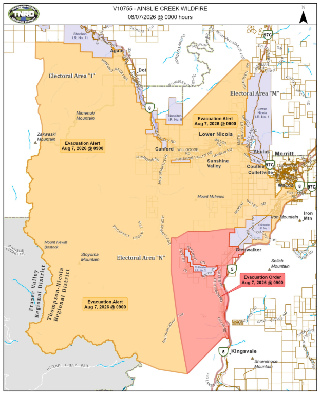
The Thompson-Nicola Regional District (TNRD) issued an evacuation order for approximately 57 addressed properties in the Coldwater/Patchett area at 9:00 a.m. Friday (Aug. 7). 

Impacted properties within Electoral Area “N” (Beautiful Nicola Valley – South) include: 

  • 240 to 280 Busby Rd.; 
  • 2060 to 2140 Suttie Rd.; 
  • 233 to 333 Gillis Rd.; 
  • 1020 to 3505 Coldwater Rd. S; 
  • 964 to 1627 Covert Pl.; 
  • 1409 to 1485 Boston Bar Trail; 
  • 921, 990, 2105, 2700 and 2725 Patchett Rd.; 
  • 2141 to 2581 Peterson Rd.; and
  • any properties as outlined on the attached map. 

Residents in any of the listed properties must leave immediately. 


(Image Credit: TNRD)

The TNRD also expanded its evacuation alert to include properties southwest of the City of Merritt. In total, 783 properties within Electoral Areas “M,” “I” (Blue Sky Country) and “N” (Beautiful Nicola Valley – South). 

  • 2309 to 3329 Aberdeen Rd.; 
  • 412 to 447 Anderson Rd.; 
  • 2184 to 2185 Armytage Rd.; 
  • 433 to 447 Bailey Ave.; 
  • 431 to 448 Barwick Ave.; 
  • 431 to 466 Brenton Ave.; 
  • 2350 to 2398 Carrington St.; 
  • 2145 to 2500 Cleasby Rd.; 
  • 68 to 1223 Coldwater Rd.; 
  • 2437 to 2560 Corkle St.; 
  • 340 to 390 Coyle Pl.; 
  • 125 to 2215 Coyle Rd.; 
  • 3141 to 3700 Cummings Rd.; 
  • 3725 to 3816 Davidson Rd.; 
  • 3425 to 3455 D’Easum Rd.; 
  • 411 to 469 Dodding Ave.; 
  • 2160 Ellis Rd.; 
  • 3069 to 3127 Fox Farm Rd.; 
  • 291 Fyall Rd.; 
  • 2185 Graham Rd.; 
  • 357 to 390 Gray Ave.; 
  • 310 to 346 Guichon Ave.; 
  • 2208 to 2215 Harris Rd.; 
  • 2177 to 2225 Hazelhurst Rd.; 
  • 1555 Hogan Rd.; 
  • 505 to 540 Humphrey Rd.; 
  • 3605 and 3685 Jack Swartz FSR; 
  • 2504 to 2736 Kinvig St.; 
  • 81 to 500 Lindley Creek Rd.; 
  • 1740 to 1868 Macaulay Rd.; 
  • 5277 to 6020 Manning Creek FSR; 
  • 473 to 529 Marshall Rd.; 
  • 254 to 2972 Merritt-Spences Bridge Highway 8; 
  • 181S Midday Valley Rd.; 
  • 188 to 818, and 1000 Midday Valley Rd.; 
  • 1256 to 1852 Miller Rd.; 
  • 325 to 361 Mingay Rd.; 
  • 425 to 464 Morgan Ave.; 
  • 1980 to 2124 Neale Rd.; 
  • 700 to 973 Neilson St.; 
  • 1601 to 1889 Nicolls Rd.; 
  • 2433 to 2504 Paige St.; 
  • 2728 to 3901 Petit Creek Rd.; 
  • 3008 to 3060 Ponderosa Ave.; 
  • 2305 to 2311 Postell St.; 
  • 2857 to 4024 Prospect Creek FSR; 
  • 2368 to 2391 Riley St.; 
  • 2264 to 2293 Schindler Cresc.; 
  • 2366 to 2466 Smith St.; 
  • 3027 to 3045 Spanish Creek Pl.; 
  • 1460 Sunnyview St.; 
  • 1441 Sunset St.; 
  • 1230 to 3069 Sunshine Valley Rd.; 
  • 3018 to 3046 Thorpe Ave.; 
  • 2124 to 2173 Tomkinson Rd.; 
  • 2380 to 2577 Torgerson Rd.; 
  • 307 to 385 Turner Ave.; 
  • 88 to 304 Veale Rd.; 
  • 2241 to 2285 Whitaker Rd.; 
  • 3009 to 3049 Wilcox Ave.; 
  • 2252 to 2440 Willgoose Rd.; 
  • 322 to 392 Winney Ave.; 
  • 429 to 492 Woodward Ave.; 
  • 2305 to 2562 Woodward Rd.; and 
  • any other properties as outlined on the attached map. 

The Coldwater Indian Band has also upgraded the evacuation alert on Paul’s Basin IR No. 2 and Coldwater IR No. 1 to an order.

The latest moves come after the TNRD previously downgraded an evacuation order for properties in Lower Nicola, Canford, Sunshine Valley and West of Spius Creek to an evacuation alert last Sunday (Aug. 2), 

The TNRD says the evacuation alert is in place to prepare residents to evacuate their premises or property should it be found necessary. While residents will be given as much advance notice as possible prior to an evacuation order, the TNRD says they may receive limited notice due to changing conditions. 

As of its latest update shortly after 9:00 a.m. Friday, the BC Wildfire Service says the Ainslie Creek wildfire within the Brunswick Complex is measured at around 40,622 hectares in size. The wildfire service says it expects aggressive fire behaviour Friday as the Ainslie Creek wildfire gets more direct sun and wind. 

The Brunswick Complex of wildfires near Boston Bar has triggered evacuation orders and alerts from the TNRD, the Fraser Valley Regional District and multiple nearby First Nations. It also caused the closure of the Trans Canada Highway through the Boston Bar area.