Pear Lake wildfire as of the BC Wildfire Service's update video on Aug. 7, 2026. (Image Credit: BC Wildfire Service)
Pear Lake Wildfire

TNRD, CRD downgrade evacuation orders for hundreds of properties near Clinton-area wildfire

Aug 10, 2026 | 9:53 AM

100 MILE HOUSE, B.C. — Hundreds of residents who were evacuated due to the massive Pear Lake wildfire near the Village of Clinton are allowed to return home. 


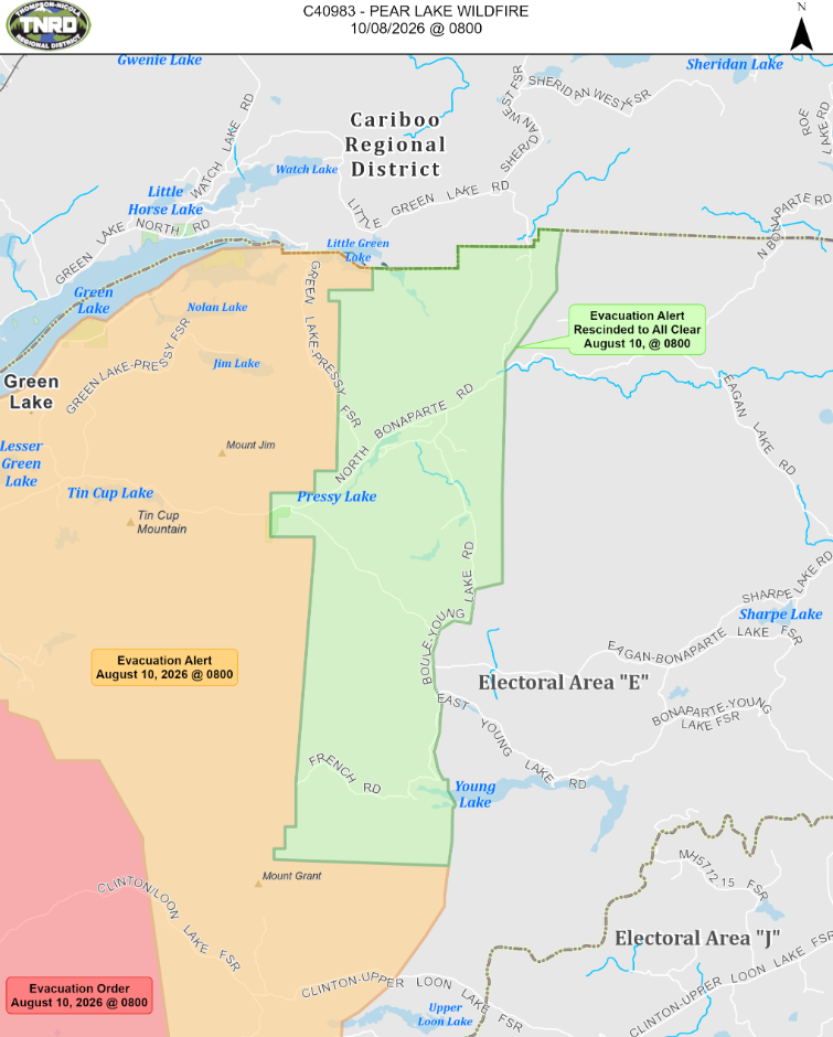
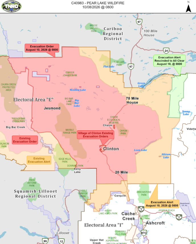
Effective 8:00 a.m. Monday (Aug. 10), the Thompson-Nicola Regional District (TNRD) downgraded an evacuation order for 672 addressed properties within the communities of Hutchinson Lake, 70 Mile House and South Green Lake. 

Those residents within Electoral Area “E” (Bonaparte Plateau) are now on evacuation alert. While residents will be given as much advance notice as possible prior to evacuation, the TNRD says they may receive limited notice due to changing conditions. 

Highway 97 from Clinton to 70 Mile remains closed due to the Pear Lake wildfire. The TNRD says residents returning to their homes in the Hutchinson Lake, 70 Mile and South Green Lake areas are told to re-enter via Highway 24 from Little Fort.


(Image Credit: TNRD)

An evacuation order is still in effect for 822 TNRD properties within Electoral Area “E.” They include: 

  • 6681 to 6697 26 Mile Frontage Rd. 
  • 900 to 985 Beaver Dam Rd. 
  • 1320 to 1380 Beaver Rd. 
  • 75 to 8065 Big Bar Rd. 
  • 800 to 1912 Chasm Rd. 
  • 7701 Clinton Station Rd. 
  • 4415 Clinton-Loon Lake FSR 
  • 98 to 200 Cornell Rd. 
  • 7511 to 7583 Danielson Rd. 
  • 2716 to 2769 Dog Creek Rd. 
  • 7228 to 7320 Elliot Park Way 
  • 7737 and 7845 Fenton Rd. 
  • 4880 to 4936 Goble Frontage Rd. 
  • 5445 High Bar Rd. 
  • 1140 and 1260 Hooke Rd. 
  • 115 to 9754 Highway 97 
  • 880, 1075, 1110 and 1402 Isadore Rd. 
  • 6421 to 10055 Jesmond Rd. 
  • 866 Lagoon Court Rd. 
  • 1876 to 1948 Lake Dr. 
  • 8856 Liden Rd. 
  • 2629 to 3193 Little Big Bar Rd. 
  • 15 to 3482 Loon Lake Rd. 
  • 1792 to 2264 Marriot Rd. 
  • 825 to 985 McCall Rd. 
  • 25 to 7628 Meadow Lake Rd. 
  • 1244 to 2025 Mound Rd. 
  • 1357 to 1832 Mound-Loon Lake Rd. 
  • 35 to 1548 Pavilion Clinton Rd. 
  • 1565 Raphael-Meason Rd. 
  • 1280 and 1285 Rench Rd. 
  • 802 and 2504 River Lake FSR 
  • 9340 Rose Rd. 
  • 1640-1672 Sands Rd. 
  • 2180 Scottie Creek Rd. 
  • 6929 to 6555 Sharp Tail Rd. 
  • 104-280 Sorley Rd. 
  • 2970 to 3103 Stevens Rd. 
  • 1090 to 1190 Tomlin Rd. 
  • 780 to 823 Valley Rd. 

Additionally, the TNRD gave the “all clear” status for nearly 128 addressed properties within Electoral Area “E.” An evacuation alert has been lifted for residents in Pressy Lake, on Little Green Lake Road and north of French Road.


(Image Credit: TNRD)

Nearly 771 addressed properties within the TNRD are now on evacuation alert.

Further north, the Cariboo Regional District (CRD) downgraded an evacuation order and lifted a pair of evacuation alerts related to the massive Pear Lake wildfire near Clinton. 

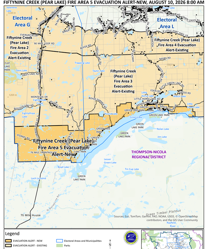
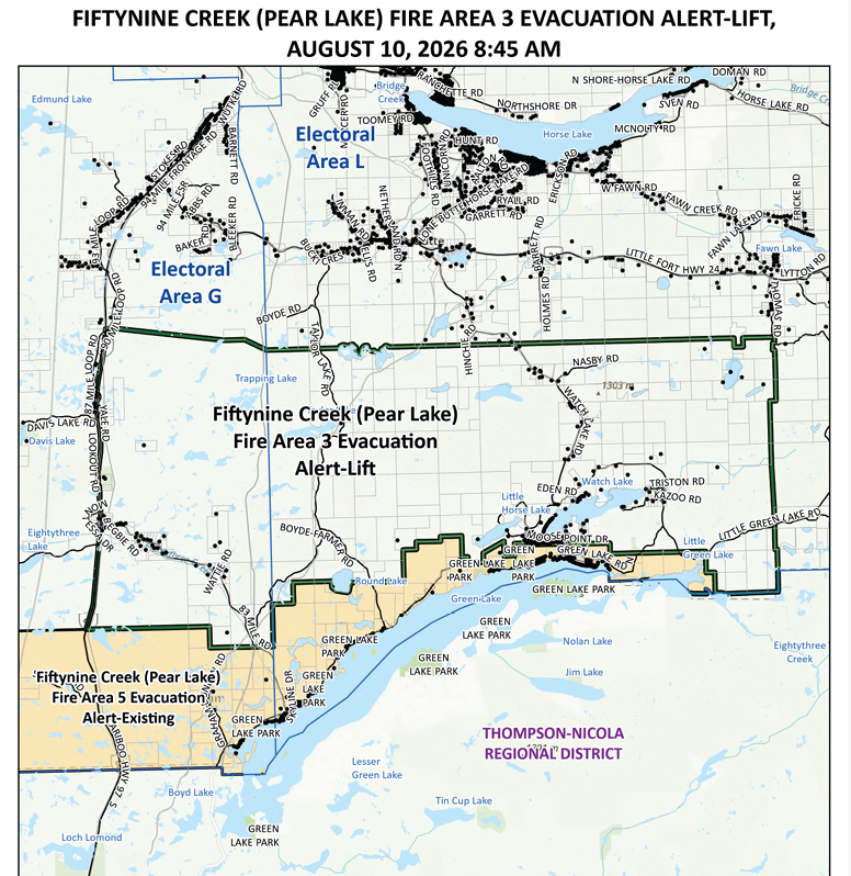
Effective 8:00 a.m. Monday (Aug. 10), the CRD says residents on nearly 366 parcels on the north end of Green Lake are able to return home. The evacuation order, which was initially placed on July 31, was replaced with an evacuation alert.


(Image Credit: CRD)

However, the CRD says residents on evacuation alert must remain ready to evacuate their property should it be required. While residents will be given as much advance notice as possible prior to evacuation, the CRD says they may receive limited notice due to changing conditions. 
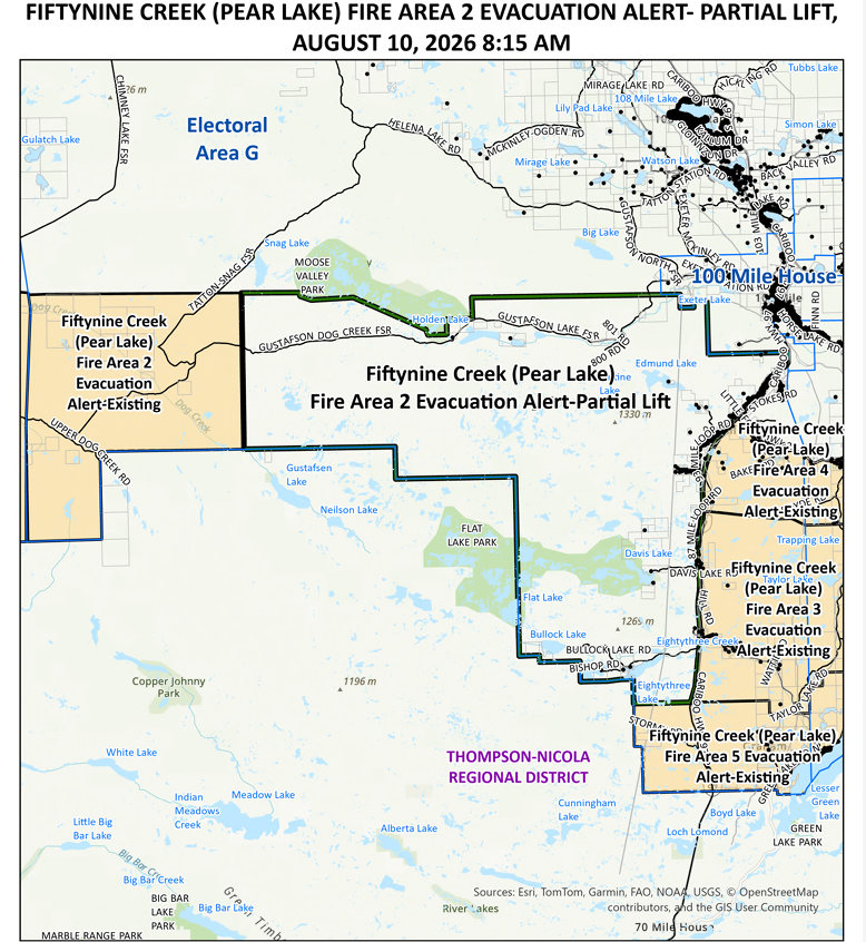
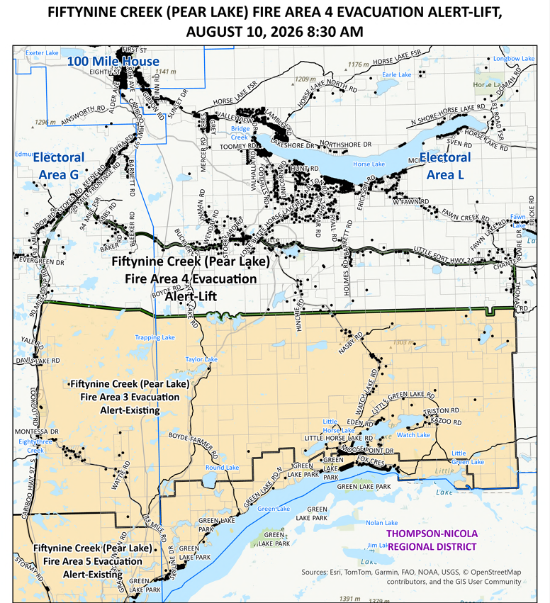
Meantime, the CRD has given the “all clear” status for multiple properties south of 100 Mile House. 

The CRD partially lifted the evacuation alert for the eastern portion of Fire Area 2 while completely rescinding the alert for Fire Areas 3 and 4. Those evacuation alerts were initially issued on July 27 and July 30, respectively.


(Image Credit: CRD)

(Image Credit: CRD)

(Image Credit: CRD)

As of publication, there are still two CRD evacuation alert areas in effect.

The Pear Lake wildfire, which is suspected to be caused by lightning, is measured at around 1,468 square kilometres (146,880.74 hectares) in size. It has triggered evacuation orders and alerts from the Village of Clinton, the Cariboo, Squamish-Lillooet and Thompson-Nicola Regional Districts, Bonaparte First Nation, Whispering Pines/Clinton Indian Band, Stswecem’c Xget’tem First Nation and Ts’kw’aylaxw First Nation. 

The Village of Clinton says there is no timeline for its residents to return home yet, although power has been restored