Pear Lake Wildfire, pictured on July 31, 2026. (Image Credit: BC Wildfire Service)
Pear Lake Wildfire

High Bar First Nation orders evacuation of reserve lands

Aug 6, 2026 | 2:20 PM

CLINTON, B.C. — Llenllenéy’ten (High Bar First Nation) has issued an evacuation order for reserve lands as the Pear Lake wildfire continues to rage out of control.

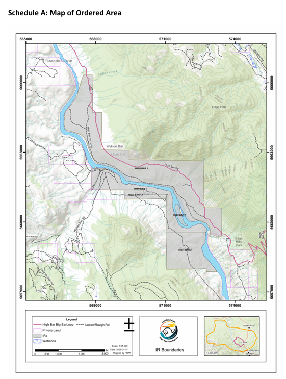
The order is in effect for High Bar I.R 1, High Bar I.R 1A, and High Bar I.R 2 effective Thursday (August 6).

Llenllenéy’ten officials said the impacts from this fire have been significant for the land and the watershed.

“What is at risk includes Llenllenéy’ten Tmícw itself, the ancestral homeland the Nation has stewarded since time immemorial. The reserve lands include the Nation’s frontage on the Fraser River, salmon fishing grounds that have connected Llenllenéy’ten families across generations and remain one of the Nation’s most direct ties to its traditional way of life,” said Llenllenéy’ten officials.

“The order reflects an assessment of extreme summer conditions, difficult access and the risk that unauthorized activity on the land, including off road vehicle use, could start new fires.”

Llenllenéy’ten said the land under the evacuation order carries a significant cultural weight for the Nation.

“Members currently cannot access the Fraser River for fishing, one of the Nation’s most important ties to its culture and traditional way of life,” said the Nation.

“This loss comes on top of other climate events that have affected Llenllenéy’ten Tmícw in recent years, including the Farwell Canyon landslide (2024), the Big Bar landslide (2019) and the Elephant Hill wildfire (2017), and it is being felt by members already carrying the weight of a difficult wildfire season.”

Llenllenéy’ten said officials met with B.C.’s Forests Minister Ravi Parmar on Wednesday (August 5), along with the Village of Clinton and the Thompson-Nicola Regional District (TNRD), to discuss the regional wildfire response and recovery planning.

This comes after the TNRD expanded its evacuation response due to the fire, which has grown to an estimated 132,598.39 hectares (about 1,326 square kilometers).

The Nation said it is contact with the BC Wildfire Service during their operations, which includes proactive and collaborative work on preventions and response.

The BCWS said firefighter crews had some challenges on the northwest and southern flanks of the fire.

“[Wednesday], we observed extreme fire behaviour and significant growth here, with the fire continuing to move south near Riley Lake and west toward the Fraser River. Elsewhere across the complex, there has been limited growth in recent days,” said the BCWS.

Ongoing drought conditions have contributed to the the fire’s continued aggressive growth, even when the winds die down.

“With winds staying light, fire behaviour and growth remain largely fuel-driven, meaning the fire advances wherever there is available fuel to carry it,” said the BCWS.

“Densely forested areas are most prone to rapid growth, while grasslands and areas burned in past wildfires help slow its progress. Even without wind, the ongoing drought continues to drive significant growth.”

You can see a map of the Llenllenéy’ten evacuation order area below.


(Image Credit: Llenllenéy’ten (High Bar First Nation))