File photo. (Image Credit: CFJC Today)
Snow Survey and Water Supply Bulletin

Final snow survey of 2026 indicates another summer of drought concern for the Kamloops area

Jun 18, 2026 | 9:59 AM

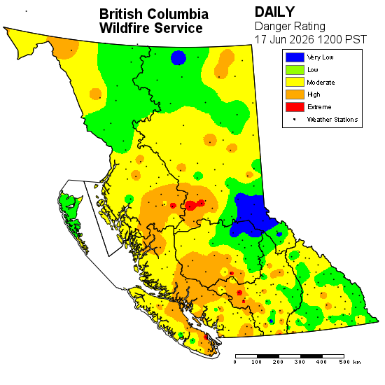
VICTORIA — The seasonal snowmelt is largely complete for the Kamloops area, with another summer of high drought hazards on the horizon. 

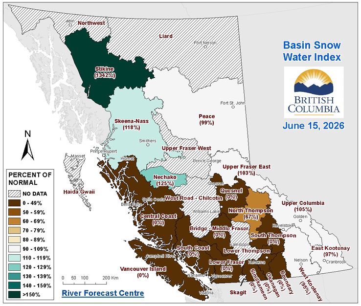
According to the final Snow Survey and Water Supply Bulletin for 2026 from the BC River Forecast Centre (BCRFC), the provincial snowpack is 48 per cent normal as of June 15, down from 64 per cent as of June 1. 

The BCRFC says 85 per cent of the measured provincial snowpack melted by mid-June, which is nearly on par to the typical 80 per cent that melts annually by June 15. However, most of the province’s remaining snowpack remains in the north and eastern sections of B.C. 

In the Kamloops area, the North Thompson basin’s snowpack was measured at 67 per cent of normal as of June 15, down from 74 per cent as of June 1 but up from 23 per cent from the same time in 2025. 

Further south and west are where conditions crater. The South Thompson, Middle Fraser (and the Lower Thompson sub-basin) and the Lower Fraser basin’s snowpack are all at zero per cent normal as of June 15. Those are down from nine, 20 and nine per cent of normal as of June 1, respectively.


(Image Credit: B.C. River Forecast Centre)

According to the seasonal outlook from Environment Canada, the southern Interior has a high probability of a warmer-than-normal summer along with a slight tendency toward below-normal precipitation. 

“Drought conditions remain a concern across portions of southern British Columbia,” the BCRFC states. “Snowmelt contributions have largely diminished across many southern basins and the development of drought during the summer will depend primarily on precipitation, temperature, evapotranspiration and water demand. The potential return of hot and dry weather through late June may accelerate drying in regions that entered the summer with below normal water supplies.” 

The fire danger rating for the Kamloops Fire Centre is mostly moderate as of 12:00 noon Wednesday (June 17), with a higher danger rating further west in the Cache Creek, Lillooet and Lytton areas.


(Image Credit: BC Wildfire Service)

As of Thursday, B.C.’s Drought and Water Scarcity Map lists the Nicola basin as experiencing Drought Level 4 conditions, while the Clearwater, Lower Thompson and South Thompson are at Level 3 and the North Thompson is at Level 2.