CFJC Today File Photo
Hot Weather

Kamloops-area temperatures remain elevated as fall approaches

Sep 13, 2025 | 3:24 PM

KAMLOOPS — While there are no heat warnings in effect for the Kamloops area, temperatures continue to remain well above seasonal levels into the middle of September, with the first day of fall a little over a week away.

Even though Environment Canada is forecasting a high of 23 C degrees on Sunday (Sept 14), which is around normal for this time of year in Kamloops, temperatures are expected to spike into the mid 20s in the early part of next week.

The weather agency was also forecasting a high of 29 C in Kamloops Saturday, though preliminary data shows the area surpassed that mark with a high of 32 C.

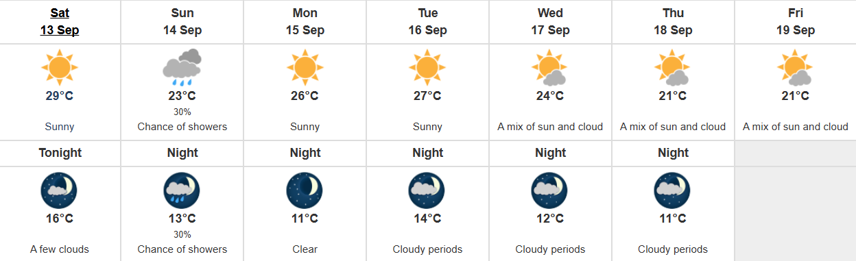
Kamloops weather forecast as of 11 a.m. on Sept. 13. (Image Credit: Environment Canada)

Speaking to CFJC Today Friday (Sept. 13), Meteorologist Matt Loney said these elevated temperatures are being caused by a “resilient ridge of high pressure” that moved into the area in late August.

“That ridge has kind of repositioned itself somewhat and we haven’t come close really to records in the past five to six days, however, the air mass is still quite warm,” Loney said. “It’s from a more southern latitude.”

Loney says changes are brewing as Environment Canada is forecasting a few storms over parts of the Interior on Sunday. In the Kamloops area, there is a 30 per cent chance of showers that day.

“The ridge isn’t quite as strong as it was and so some storm will punch through from the Pacific,” Loney said. “We call it an upper trough and that’s going to slip over the area. We’re also expecting a bit of a more vigorous trough for next Wednesday so we expect to see a bit of moisture come in.”

“Beyond that, the models are kind of not giving us as clear as indication on what’s going to go on. Whether the through is going to linger or whether we’ll see another ridge build in. the latter part of next week is really a crapshoot as to what is going to happen.”

Loney also told CFJC Today that these warmer than usual temperatures can lead to an increased chance for temperature inversions – where the ground is cooler than the air. He noted those inversions tend to trap smoke and other pollutants near the ground, which can exacerbate issues like the one experienced at the Kamloops pulp mill Friday.

“Especially in the morning, we get cooling at the surface compared to the higher altitude, and so that’s the ideal time for pollutants to get trapped near the surface,” Loney said.

“As we get towards midday and the afternoon, that area where pollutants can get trapped can actually expand and go higher so the pollutants can mix out a little bit better as the day wears on.”

This prolonged period of hot and dry weather has also caused the drought level on the North and South Thompson River basins to increase slightly.

You can find the latest Environment Canada forecast for Kamloops here.