CFJC File Photo
High Water

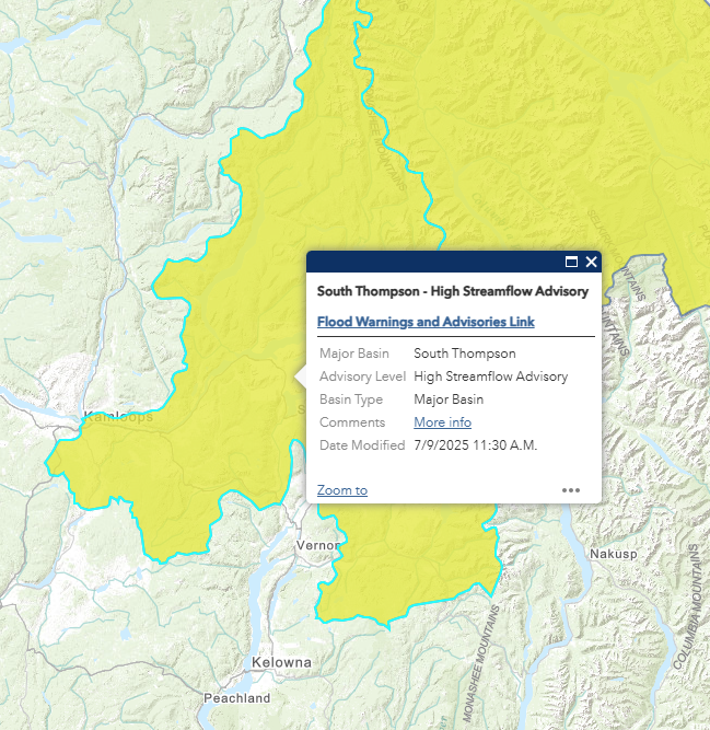
UPDATE: High streamflow advisory, special weather statement lifted as rain subsides

Jul 10, 2025 | 6:33 AM

KAMLOOPS — (UPDATE 11:00 a.m.): The high streamflow advisory and the special weather statement have both been lifted.

EARLIER — A High Streamflow Advisory remains in effect for the South Thompson River basin following the spell of rainy weather on Wednesday (July 9).

The advisory covers the tributaries of the South Thompson including areas in the Monashee Mountains and areas east of Salmon Arm as well as the Upper Columbia River and its tributaries including areas around Golden, Revelstoke and Three Valley Gap.

“Current weather forecasts have the heaviest rainfall focused on the northern Monashee Mountains and Thompson Plateau,” a statement from the BC River Forecast Centre said. “Adjacent areas in the Upper Columbia region may also experience moderate to heavy rainfall.”

A High Streamflow Advisory issued for the South Thompson Wednesday, July 9 (Image Credit: BC River Forecast Centre)

The BC River Forecast Centre is urging caution as it notes the rain could cause water levels to rise Wednesday and Thursday, which may lead to localized flooding in low-lying areas.

“There remains uncertainty as to the exact locations and rainfall totals,” the River Forecast Centre added. “High-end scenarios indicate the potential for localized rainfall amounts reaching up to 80 mm to 100 mm with enhancement of rainfall anticipated from embedded thundershowers.”

A special weather statement also remains in effect as Environment Canada says the area from Ashcroft to Three Valley Gap could be inundated by heavy rain and isolated thunderstorms.

You can find the latest from the BC River Forecast Centre here, and the latest weather alerts from Environment Canada here.