File Photo (Image Credit: CFJC Today)
Heat Wave Update

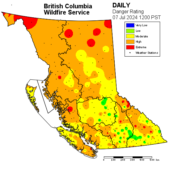
Higher temperatures in Kamloops and area lingering into next week; forecasters keeping an eye on dry lightning

Jul 8, 2024 | 12:30 PM

KAMLOOPS — The heat wave that’s been blanketing most of B.C., including Kamloops and area, is expected to start to taper off Wednesday (July 10) night.

In a news conference Monday morning, Environment Canada forecasts that the high temperatures from the ridge of high pressure will shift southeast through the week.

However, the weather agency says the warm spell will likely linger into next week.

Armel Castellan, a meteorologist with Environment Canada, says B.C.’s Southern Interior will remain under a heat warning for the coming days. While temperatures are set to ease, he says they will be about eight to nine degrees above the seasonal norm for the remainder of the week.

“Those will be just shy of the heat warning criteria, but they are not looking to go below seasonal values, which would be closer to 26 degrees during the daytime and 11 overnight,” Castellan says. “That’s probably true well into the forecast, probably until the end of July at the earliest.”

In the short term, Castellan says Environment Canada is keeping a close eye on Tuesday afternoon and Wednesday. He says as the ridge of high pressure breaks down, a window could open for a front to bring dry lightning through B.C.’s Southern Interior.

“We’re having close collaborations with the BC Wildfire Service to discuss how to warn our emergency management colleagues,” Castellan says. “This could be a very important date that we remember because the wildfire concerns are gaining steam very quickly over an event like this one.”

As of noon Sunday, the BC Wildfire Service’s fire danger rating shows the Kamloops Fire Centre’s risk mostly ranging from moderate to high.

Image credit: BC Wildfire Service
View Comments