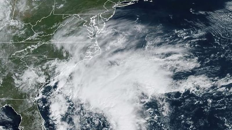
Tropical Storm Ophelia forms off the US mid-Atlantic coast, expected to bring heavy rain and wind

Sep 22, 2023 | 11:06 AM

MIAMI (AP) — Tropical Storm Ophelia has formed off the mid-Atlantic coast and is expected to bring rain, storm surge and windy conditions over the weekend, the National Hurricane Center said.

Ophelia had maximum sustained winds of 60 mph (95 kph), according to a 2 p.m. ET advisory from the Miami-based center. The storm was centered 150 miles (240 kilometers) southeast of Cape Fear, North Carolina. The storm was forecast to make landfall Saturday morning.

THIS IS A BREAKING NEWS UPDATE. AP’s earlier story follows below.

MIAMI (AP) — An intensifying weather system off the U.S. mid-Atlantic coast was set to deliver heavy rain, flooding and high winds to communities across North Carolina and the Chesapeake Bay, forcing schools to close early on Friday and canceling weekend events.

Rain was already moving inland across North Carolina by midday Friday ahead of landfall early Saturday, with some areas expected to get up to 7 inches (17.7 centimeters) across eastern parts of the state and into southeast Virginia, forecasters said.

With top sustained winds of 50 mph (85 kph), the system has reached tropical storm strength but was still being referred to as Potential Tropical Cyclone Sixteen by meteorologists at the National Hurricane Center. A storm surge warning was in effect for some areas, with surges between 3 and 5 feet (0.9 to 1.5 meters) forecast for parts of North Carolina, the center reported.

“Regardless of what we’re calling it, the impacts are going to be much the same — widespread impacts from tropical storm force winds, storm surge, heavy rainfall and flooding,” Mike Brennan, the center’s director, said in a livestreamed briefing on Friday.

The hurricane center defines a potential tropical cyclone as a disturbance posing a threat of tropical storm or hurricane conditions to land within 48 hours.

The system’s center is expected to come ashore in North Carolina early Saturday, move inland over eastern North Carolina and southeastern Virginia and near the Chesapeake Bay through the day on Sunday, Brennan said.

The weather was already affecting water taxis in Maryland’s capital, Annapolis. Scott Bierman, a water taxi driver, said service would shut down at 6 p.m., and the decision had already been made to close Saturday.

“We don’t operate when it’s going to endanger passengers and or damage vessels,” Bierman said.

Virginia Gov. Glenn Youngkin declared a state of emergency Friday afternoon, issuing an executive order intended to ease response and recovery efforts.

“As this storm has organized and strengthened, it’s becoming clear based on the latest forecasts that impacts to the commonwealth are likely,” Youngkin said in a statement. “We want to ensure that all communities, particularly those with the greatest anticipated impact, have the resources they need to respond and recover from the effects of this storm.”

The governor encouraged residents to prepare an emergency kit and follow the weather forecast closely.

Schools in coastal areas of North Carolina and Virginia announced plans to dismiss students early Friday and cancel afterschool and weekend activities.

The storm was located about 255 miles (405 kilometers) east of Charleston, South Carolina, and about 200 miles (320 kilometers) south Cape Hatteras, North Carolina, and moving north around 12 mph (19 kph), the hurricane center said.

The North Carolina Ferry System announced it was suspending several routes and the State Emergency Response Team planned to move to an enhanced watch Friday to ease coordination of resources, the governor’s office said.

The forecast prompted the cancellation of events across the region, including the Kunta Kinte Heritage Festival, which had been set to return to City Dock in Annapolis on Saturday.

A storm surge warning was in effect from Duck, North Carolina, to Chincoteague, Virginia, including Chesapeake Bay south of Windmill Point, and for the Neuse River, the Pamlico River, and portions of Pamlico Sound.

A storm surge watch also was issued from Surf City in North Carolina to Duck, North Carolina, along with Chesapeake Bay north of Windmill Point to Smith Point, the Tidal Potomac south of Colonial Beach and Albemarle and the remainder of Pamlico Sound.

Meanwhile, Hurricane Nigel was downgraded to a post-tropical cyclone centered about 640 miles (1,030 kilometers) northwest of the Azores with maximum sustained winds of 70 mph (110 kph). There were no associated coastal watches or warnings as the storm moved northeast at 37 mph (59 kph), the hurricane center said in its final update on the system Friday morning.

___

Follow AP’s climate coverage at: https://apnews.com/hub/climate-and-environment

The Associated Press