Image Credit: B.C. Electoral Boundaries Commission
Electoral Boundaries Commission

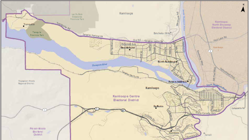
Proposed new electoral map would see big changes around Kamloops

Oct 3, 2022 | 4:31 PM

VICTORIA — The B.C. Electoral Boundaries Commission has tabled a preliminary report, suggesting the number of ridings in the province increase by six to 93.

The six ridings would include four in the Lower Mainland, one west of Victoria and one near Kelowna.

If it’s adopted, the new electoral map would see significant changes around Kamloops.

The commission recommends a Kamloops-Centre riding that would encompass the city’s “urban core” as well as surrounding neighbourhoods of Aberdeen, Dufferin, the Thompson Rivers University precinct, North Kamloops and Brocklehurst. Rural areas to the west of the urban centre would join Fraser-Nicola.

Rural areas east of the core would join the newly-drawn riding of Kamloops-North Shuswap. This riding would include the Kamloops neighbourhoods Westsyde and Rayleigh, a portion of the North and South Thompson valleys, much of the North Shuswap region, and the communities of Pritchard and Chase.

The Shuswap riding presently represented by MLA Greg Kyllo would be renamed Salmon Arm-Shuswap and would be decreased in size in line with other Interior ridings.

The boundaries of Fraser-Nicola would be increased slightly.

To the north, the Cariboo-Chilcotin riding would be renamed Cariboo-North Thompson and would include the communities of Williams Lake, Lac la Hache, 100 Mile House, Anahim Lake, Clearwater and Barriere.

The preliminary report is published below.

The commission will now hold a series of final public meetings, including one in Kamloops on October 18. Virtual public hearings will be held on October 21 and November 8.

View Comments