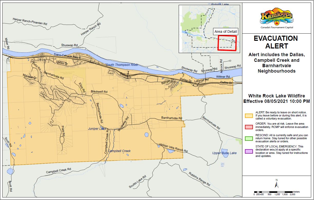
Barnhartvale, Campbell Creek, and Dallas areas in Kamloops placed on Evacuation Alerts/Orders
-
Share on Facebook
-
Share on Bluesky
-
Share on X
- Copy Link
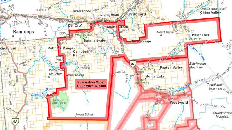
KAMLOOPS – The Thompson-Nicola Regional District has issued an Evacuation Order for 303 properties in Electoral Area “L” in the vicinity of Westwold/Monte Lake, which were previously on an alert, due to the White Rock Lake Wildfire.
The Evacuation Order includes the southeastern border of the City of Kamloops. The following properties are impacted:
• 2, 10, 515 and 525 Barnhartvale Rd;
• 1048 to 2179 Barnhartvale Rd;
• 2370 to 2912 Barnhartvale Rd;
• 9760 and 9940 Barnhartvale Rd;
• 1524 to 1659 Bostock Rd;
• 3461 to 5165 Campbell Range Rd;
• 3864 to 4745 Chase-Falkland Rd;
• 956 to 2160 Dallas Dr;
• 4545 to 4585 Demarni Rd;
• 3941 Duck Range Rd;
• 6265 to 6325 Eden Rd;
• 6828 to 6910 Faulk Rd;
• 3342 to 3625 Garrett Rd;
• 4080 to 4195 Gowan Rd;
• 2881 and 2930 Hanna Rd;
• 9052 to 9710 Hidden Vale Ranch Rd;
• 1257 to 2547 Hook Rd;
• 2600 to 3375 Hwy 97;
• 6459 to 6780 Karjula Rd;
• 1677 to 1685 Lute Rd;
• 3880 to 3946 Maddox Rd;
• 6725 to 6888 Martin Prairie Rd;
• 4620 Martinson Rd;
• 2412 to 2776 Miners Bluff Rd;
• 1534 to 1760 Monte Creek Rd;
• 4705 Moore-Richardson Rd;
• 4139 to 4523 Moser Rd;
• 5723 to 6940 Paxton Valley Rd;
• 2280 to 6080 Robbins Range Rd;
• 7160 and 7200 Roche Lake Rd;
• 4845 Sinclair Rd;
• 5209 Six Mile Creek Rd;
• 7000 Smith Lake FSR
• 1121 to 1655 Watson-Larson Rd; and
• any properties with the boundary outlined on the map below.
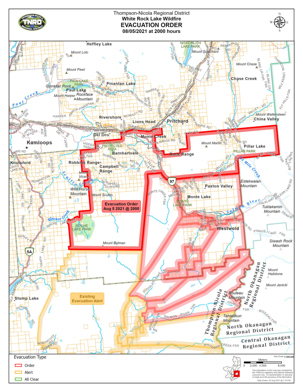 Image Credit: TNRD Evacuation Order for properties in Electoral Area “L”