Snowpack level higher than normal in Thompson region though flood risk remains moderate

Apr 9, 2018 | 1:49 PM

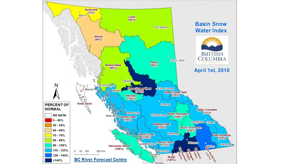
KAMLOOPS — The Thompson region is facing a “moderate flood risk” this spring.

Jonathan Boyd, hydrologist with the BC River Forecast Centre, made the comment during a conference call discussing the April Snow and Water Supply Bulletin Monday.

The report found both the North and South Thompson Rivers have a snowpack of 109 per cent of normal. 

However, he said snowpack is just one component when measuring the flood risk each year. 

Speaking specifically on the flood risk in Kamloops, Boyd said it would take seven to 10 days of at least 25 degree temperatures to increase the flood risk here.

“All it takes is all of the snow to melt in one week followed by an intense storm to potentially threaten and cause flooding,” said Boyd.

He said another component could be the hydrological effects of last year’s devastating wildfires.

“Kamloops won’t be at risk with that, it’ll be more the Cache Creek area that will be higher risk. Also, the Bonaparte River is in the Cache Creek area though we’re expecting the areas to be affected to be quite isolated.”

Boyd said there will be more debris in creeks and rivers going downstream from the affected areas and what that can lead to is erosion along banks or dykes that are protecting areas.

He said areas where the flood risk is greater include the Okanagan and Similkameen where the snow pack is sitting at 152 per cent of normal.

Boyd added the April Snow and Water Supply Bulletin is the most important of the year because by April 1 about 95 per cent of the average snowpack has accumulated.